Langtang Trek: Dhunche -> Kyangjin
Nach etwa sieben Stunden Bus- oder Taxifahrt von Kathmandu erreicht man Dhunche, hoch über dem Trisuli Fluss, den Ausgangspunkt für das Langtang Trekking mit herrlichem Blick auf den 7246 m hohen Langtang Lirung. Drei Tagesetappen von jeweils etwa 5-6 Stunden führen von Dhunche über Syabru und Lama Hotel nach Langtang. Nach weiteren drei Stunden ist man in Kyangjin, dem hintersten Ort des Langtang Tales. Zurück nach Dhunche kommt man in drei Tagesetappen. Wer mehr Zeit hat, sollte den Weg über Syabru, Shin Gompa, Gosainkund, Tharepati nach Sundarjal nehmen (insgesamt 6 Tage von Syabru mit Blick auf Ganesh Himal, Manaslu und Annapurna, sowie in die Langtangberge bis zum Everest von Tharepati aus).
In umgekehrter Richtung sollte man zwischen Tharepati und dem Laurebina Pass wegen des langen Aufstiegs eine Übernachtung einplanen. Wir hatten zum Jahreswechsel 1996-97 zwei Wochen herrliches Wetter, kaum Touristen und nur am Laurebina Pass etwas Schnee. Es gab in allen genannten Stationen (insbesondere Gosainkund und zwischen Laurebina Pass und Tharepati) bewirtschaftete Lodges zum Übernachten (nur warmer Schlafsack erforderlich). Ein Jahr zuvor lag zur gleichen Zeit viel Schnee im Langtang und der Laurebina war unpassierbar, so dass sich beispielsweise der Helambu Trek angeboten hätte.
After a 7 hours drive by bus or taxi from Kathmandu Dhunche high above the Trisuli River is reached. The village with an phantastic view of the 7246 metre peak Langtang Lirung marks the starting point for the Langtang Trek. A three days hike (each day about 5-6 hours of walking) leads from Dhunche via Syabru and Lama Hotel to Langtang. Another three hours and Kyjangjin, the final village in the Langtang Valley is reached. The return to Dhunche takes again 3 days. If you've got the time we recommend to take the route via Syabru, Shin Gompa, Gosainkund, Tharepati to Sundarjal for the way back. It takes 6 days from Syabru and you have an exceptional view of Ganesh Himal, Manaslu and Annapurna as well as the Langtang mountains up to Everest at Tharepati.
Doing this part of the trek in opposite direction one should plan an additional overnight stay between Tharepati and the Laurebina Pass because of the very long ascent. At new year 1996-97 we had two weeks of phantastic weather with only few other tourists and little snow on the Laurebina Pass. At all places mentioned above (especially at Gosainkund and between Laurebina Pass and Tharepati) we found hosted lodges to stay overnight which only afforded a warm sleeping bag. One year before at the same time of the year the traverse of the Laurebina Pass was impossible due to the amount of snow. In this case the Helambu Trek would have been an alternative.
 |
 |
Dhunche (1900 m) erreicht man nach siebenstündiger Fahrt von Kathmandu aus. Der Höhenweg führt durch Bergwälder und über Almen, wo man auch im Winter einkehren kann. Der Blick geht nach Norden zu den Sechstausernden der tibetischen Grenzkette. Immer eindrucksvoller wird der Blick auf den Ganesh Himal im Westen.
We started the trek at Dhunche (1900 m) which we reached after a 7 hours drive from Kathmandu. The path leads in northern direction through forests and across alpine pastures. Already visible are the 6000 metre peaks on the border to Tibet. In the west Ganesh Himal appears.
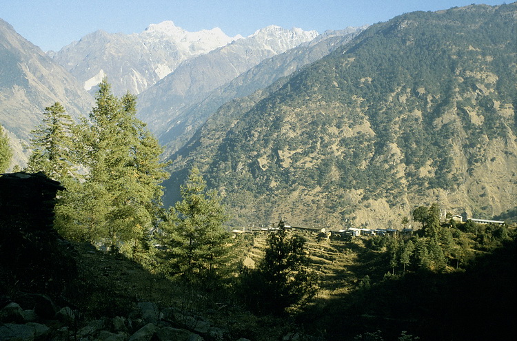
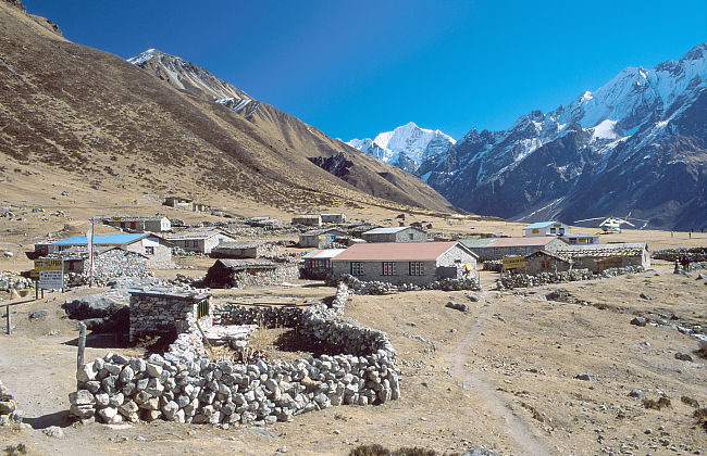
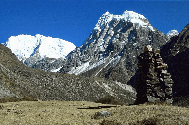
Blick auf den Ganesh Himal bei Gompagaon. Blick nach Osten über die Schlucht des Langtangflusses hinweg. Noch sind die hohen Berge nicht sichtbar. Im Vordergrund das auf einem ausgeprägten Rücken liegende Dorf Syabru (2400 m) mit mehreren Lodges zum Übernachten.
View to Ganesh Himal range from Gompagaon. View to the east across the valley of the Langtang river. The high mountains are not yet visible. Opposite the village of Syabru (2400 m) with quite a few lodges to stay overnight.
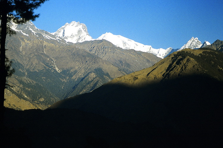
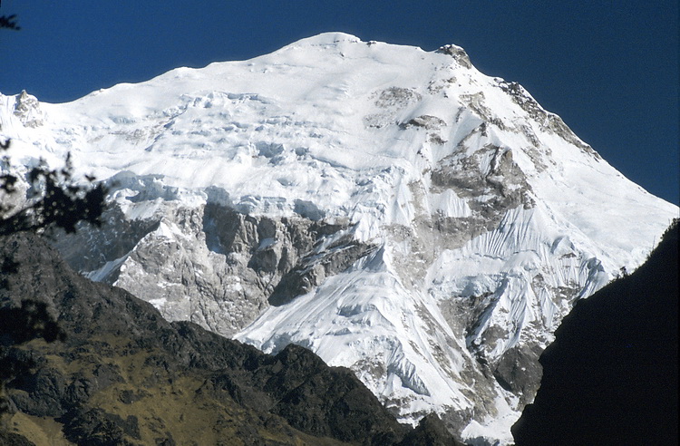
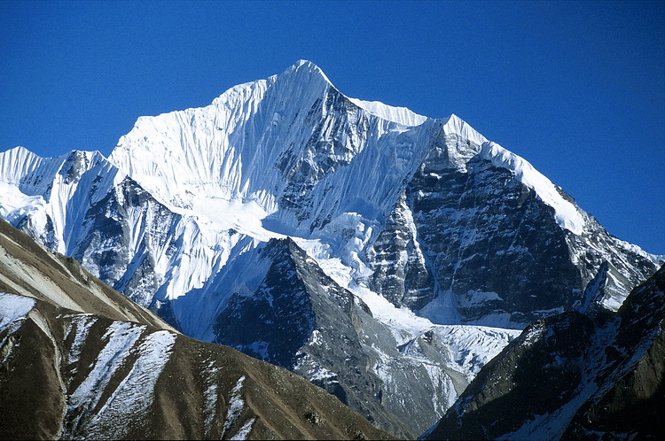
Morgendlicher Blick zu Ganesh V (6950 m), Ganesh I (7406 m) und Ganesh VII (6350 m) von Syabru aus, das man in etwa 5 Stunden Gehzeit von Dhunche erreicht. Die nächste Tagesetappe führt durch die Langtangschlucht zu der Siedlung 'Lama Hotel'. Der Höhenunterschied vom Langtangfluss zum Gipfel des Langtang Lirung (7246 m) beträgt hier fast 5 km.
Early morning view to Ganesh V (6950 m), Ganesh I (7406 m) and Ganesh VII (6350 m) from Syabru which lies about 5 hours north of Dhunche. The next day leads through the Langtang canyon to the settlement of 'Lama Hotel'. The difference in altitude from the Langtang river to Langtang Lirung (7246 m) is about 5 km.
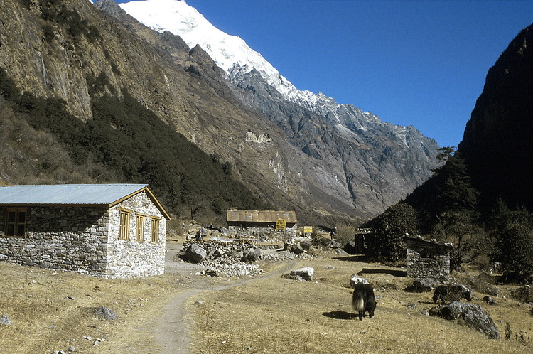 |
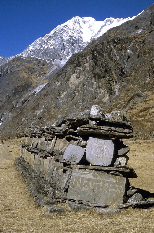
Ab Ghore Tabela ändert sich der Charakter des Tals. Das durch den Langtang Fluss tief eingeschnittene Langtangtal weitet sich zu einem U-förmigen Gletschertal. At Ghore Tabela the character of the valley changes. The Langtang Valley which is carved out deeply by the Langtang River now widens to u-shaped valley of glacial origin. |
 |
Von Langtang führt eine kürzere Etappe zum hintersten Ort des Tales nach Kyangjin. Blick nach Westen zum Chenge Lirung (6571 m). It takes about 3 hours to get from Langtang to Kyangjin near the end of the Langtang Valley. View towards Chenge Lirung (6.571 m). |
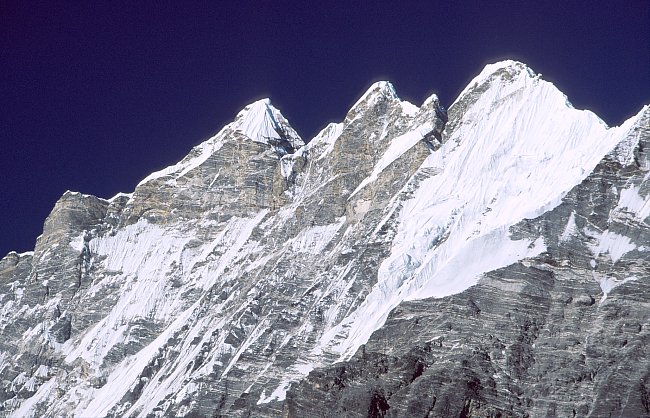
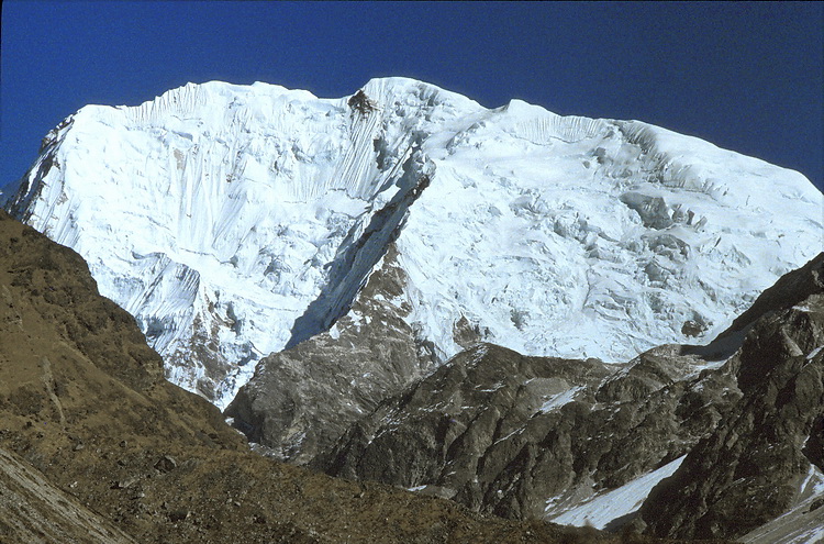
Kyangjin liegt auf etwa 3900 m mit schönem Blick auf den dreigipfeligen Tsangbu Ri (6745 m) und den Kang Chenpo (6297 m) am Ende des Tals. Über die Hänge links im Mittelgrund führt ein Pfad auf einen bequem erreichbaren Aussichtspunkt auf etwa 4400 m Höhe.
The triple summit of Tsangbu Ri (6.745 m) east of Langtang Lirung and Kang Chenpo (6.297 m - at the end of the valley) seen from Kyangjin. The slopes to the left lead to an easy accessible vantage point at approximately 4.400 m.
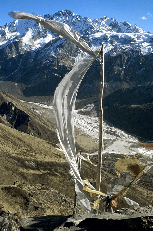
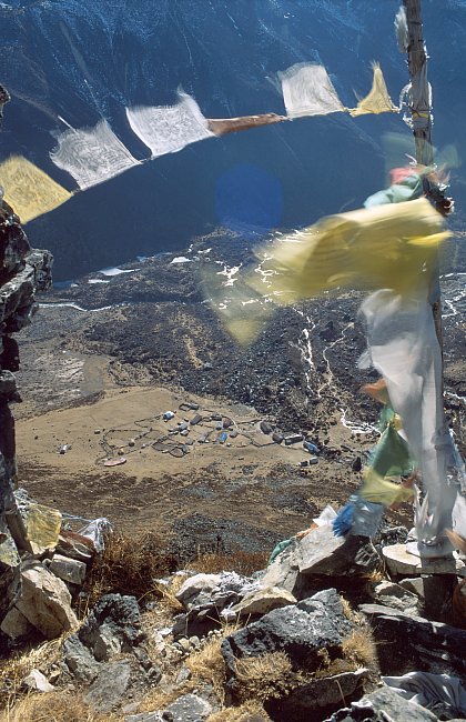
Diese Nachmittagstour lohnt sich nicht nur wegen der Akklimatisation. Man geniesst auch eine prächtige Aussicht auf Kang Chenpo und den Weg zum Ganja La (rechts ausserhalb des Bildes) im Osten. Im Tal liegt Kyangjin.
This afternoon hike is worthwile not only for acclimatisation purposes. It also includes a fine view eastwards to Kang Chenpo and the route to Ganja La (to the right - outside the picture). In the valley below: the village of Kyangjin.

Eine lohnende Tageswanderung von Kyangjin aus führt ins innerste Langtang Tal bis zur Moräne des Langtang Gletschers. Über das ehemalige Flugfeld geht der Blick westwärts nach Kyangjin und zum Langtang Lirung.
Another day's hike leads from Kyangjin to the inner Langtang Valley up to the moraine of the Langtang Glacier. Across the former air-strip we are looking westward to Kyangjin and Langtang Lirung.
Von Nubamathang (4100 m) im inneren Langtang Tal hat man einen eindrucksvollen Blick auf den Pemthang Karpo Ri (6830 m) und den Langshisa Ri (6145 m).
From Nubamathang (4.100 m) one has an impressive view of Pemthang Karpo Ri (6.830 m) and Langshisa Ri (6.145 m). Pemthang Karpo Ri.