Radüner Rothorn
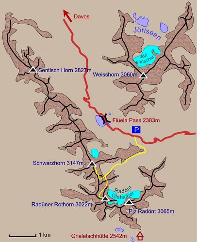
Der Flüela Pass (2383 m) stellt eine wichtige Verbindung zwischen dem Prättigau mit dem mondänen Luftkurort Davos und dem Unterengadin dar und ist Ausgangspunkt zahlreicher Bergwanderungen und Skitouren wie Pischahorn, Gorihorn, Sentisch Horn, Schwarzhorn oder Weisshorn (leichte Blockkletterei, nicht als Skitour geeignet).
Ausserdem wird der Weg über die Fuorcla Radönt oft als Zugang zur Grialetschhütte benutzt. Unsere Auswahl stellt das Gebiet um das Radüner Rothorn (3022 m) und den Wander-Dreitausender Flüela Schwarzhorn (3147 m) vor. Ausgangspunkt war das Flüela Hospiz, der Höhenunterschied etwa 700 m bzw. 800 m und die Gehzeit ca. 3 Stunden.
The Flüela Pass (2383m) is an important connection between the Prättigau area with its well known health resort of Davos and the lower Engadin. It is the basis for numerous hikes to the surrounding summits of Pischahorn, Gorihorn, Sentisch Horn, Schwarzhorn and Weisshorn (easy climbing but not recommended as ski tour).
The Fuorcla Radönt gap is also frequently used as traverse to theGrialetsch Hut. We chose the area around Radüner Rothorn (3022 m) and Flüela Schwarzhorn (3147m). Starting at the Flüela Hospiz hotel the difference in altitude was 700 m / 800 m and it took us about 3 hours to get there.
 |

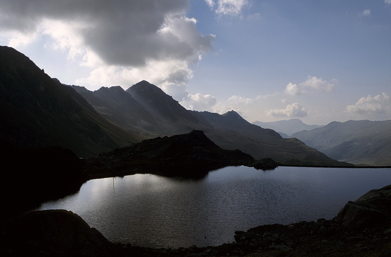
Das Flüela Hospiz auf der Passhöhe ist ein beliebter Stopp für Wanderer und Biker. Stimmungsvoller abendlicher Blick zum Sentisch Horn (2827m - Bildmitte) und der Davoser Weissfluh im Hintergrund.
On top of the Flüela Pass the Flüela Hospiz is a popular stop for hikers and bikers. Evening view towards Sentisch Horn (2827m - center) Davoser Weissfluh behind.
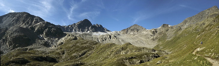
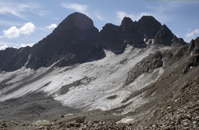
Anstieg zum Flüela Schwarzhorn (3147 m - ganz rechts). Unterhalb des Felshöckers mit dem kleinen Schneefeld biegt eine Pfadspur zum Radüner Rothorn (3022 m, rechts der Bildmitte) ab. Vom Radönt Gletscher unterhalb des Piz Radönt (3065m - links der Bildmitte) sind nur noch Moränen sichtbar.
The ascent of Flüela Schwarzhorn (3147m - right). Just below the rock with the little snow-field the path to Radüner Rothorn (right of the center) turns left. Below Piz Radönt (3065m - left of the center) the leftovers of the former Radönt Glacier are visible.

An der Weggabelung zum Schwarzhorn und zur Radüner Rothorn Furgga (über das Radüner Rothorn) schweift der Blick nach Nordosten zu den Plattenhörnern (3220 m - Hintergrund links der Bildmitte) und dem Piz Linard (3411m - höchster Silvretta Gipfel). Der Anstieg erfolgt von rechts nach links in leichter Blockkletterei und auf Wegspuren über den Nordgrat.
Where the path to Schwarzhorn and Radüner Rothorn gap (which is reached traversing the Rothorn) divides we get a first impression of the Silvretta Range with Plattenhörner (3200m - left of the center) and Piz Linard (3411m - the highest summit of the Silvretta area). Easy climbing and partly tracks lead to the summit via the north ridge.
 |
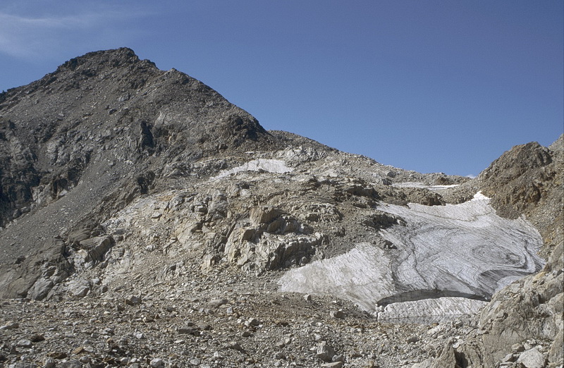
Piz Radönt (3065 m - links) und Radüner Chöpf (3020 m - rechts). Über den Radönt Gletscher in Bildmitte und den Südosthang führt der Skianstieg auf das Radüner Rothorn. Im Sommer ist von diesem Anstieg wegen Blankeis und Steinschlag abzuraten. Piz Radönt (3065 m - left) and Radüner Chöpf (3020 m - right). The ski route to Radüner Rothorn leads across the Radönt Glacier and the south east ridge. In summer this ascent can not be recommended because of hard ice and rockfall. |
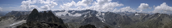
Das Gipfelpanorama reicht von den Ötztaler Alpen bis zum Piz Kesch im Westen.
The summit panorama starts with the Ötztal Alps to left up to Piz Kesch to the west.


Blick vom Radüner Rothorn auf den Grialetsch Gletscher mit dem idealen Skiberg Piz Sarsura (3178m - links der Bildmitte) und der Grippa Naira (3130 m) mit dem Hängegletscher. Rechtes Bild: der Piz Kesch (3418 m), ebenfalls ein berühmter Skigipfel, den man von der Keschhütte ersteigt. Das Skidepot erfolgt dort, wo der Porchabella Gletscher am weitesten hinaufreicht. Rechts dahinter der Piz Ürtsch (3268 m) und rechts mit dem kleinen Gletscher das Chüealphorn (3078 m) ein weiterer Skiberg mit Ausgangspunkt Sertig- oder Dischmatal.
View from the top of Radüner Rothorn to the Grialetsch Glacier with the ideal ski summit of Piz Sarsura (3178 m - left of the center) and Grippa Naira with its seracs. Right picture: Piz Kesch (3418 m) another well-known ski summit which is climbed from the Kesch hut. The skis are left behind on the topmost part of the Porchabella Glacier. Behind Piz Ürtsch (3268 m) and to the right Chüealphorn (3078 m) another ski summit which can be climbed from the Sertig- or Dischma Valley.
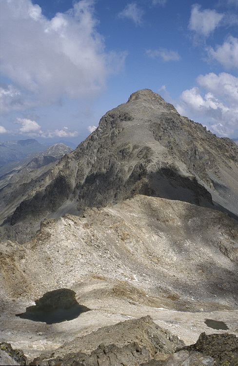 |
Auf den Gipfel des Flüela Schwarzhorns (3147m) führt ein guter Wanderweg über den Schuttrücken. Über dieselbe Route erreicht man den Gipfel auch mit Skiern. Das Flüela Weisshorn (3085 m) wird von der Winterlücke über den Nordwestgrat über Geröll und Blockkletterei erstiegen. A good path leads to the top of Schwarzhorn (3147m) across the debris covered ridge which is also used as ski tour. Flüela Weisshorn (3085 m) opposite the Flüela Pass is climbed via its north western ridge (easy rock climbing). |
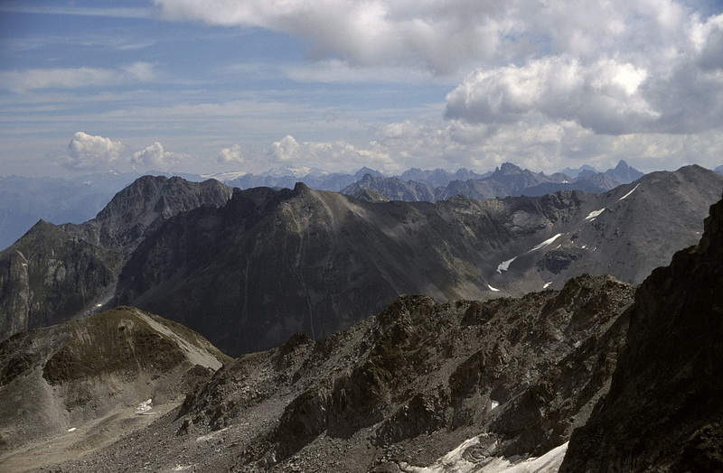

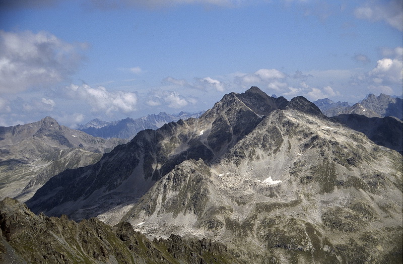
Blick vom Radüner Rothorn zu den Ötztaler Alpen links der Bildmitte und den Engadiner Dolomiten rechts davon. Aus der linken Ecke führt der Weg vom Flüela Pass über die Fuorcla Radönt (2788 m) ins Val Grialetsch und zur Grialetschhütte.
Left of the center the Ötztal Alps and the Engadine Dolomites to the right. The path leading from Flüela Pass to the Grialetsch Hut crosses the Fuorcla Radönt gap (2788 m) in the foreground.