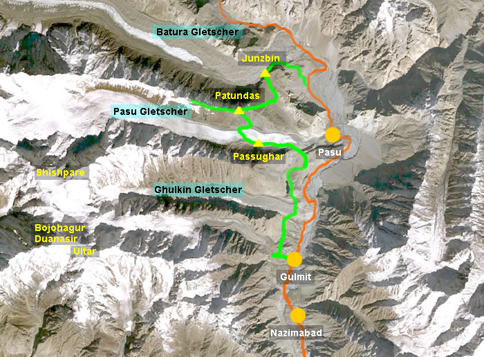
Patundasrücken und Baturagletscher
Der Patundasrücken ist ein Lagerplatz der Extraklasse hoch über dem viertlängsten Gletscher des Karakorum. Die Tour führt zunächst vorbei an Ghulkingletscher und Borith See zum Lagerplatz auf der Seitenmoräne des Pasugletschers, welcher am folgenden Tag gequert wird. Nach einem steilen Anstieg über 900 Höhenmeter erreicht man den Patundasrücken zwischen Pasu- und Baturagletscher. Wandert man den Rücken entlang, ergeben sich immer wieder faszinierende Ausblicke, wenn das Wetter mitspielt. Über steile und teilweise ausgesetzte Hänge mit Schiefergeröll geht es dann wieder hinab nach Junzbin (2900 m), unserem letzten Zeltlager, von wo aus man in ca. 2 Stunden den Karakorum Highway ereicht.
The Patundas Ridge is a very special campsite high above the fourth longest glacier of the Karakoram Range. On the first part of the hike we passed Ghulkin Glacier and Borith Lake and erceted the camp on the moraine of the Pasu Glacier which we traversed the next day. After a steep ascent of about 900 m we reached the Patundas Ridge, an excellent panorama place between Pasu- and Batura Glacier. A walk along the ridge to a panorama point at 4300 m turned out to be a foggy experience but should be very impressive on clear days. Across steep and partly exposed slopes of slate debris we descended to Junzbin (2900) our last campsite from where the Karakoram Highway can be reached in another 2 hours.
 |
 |
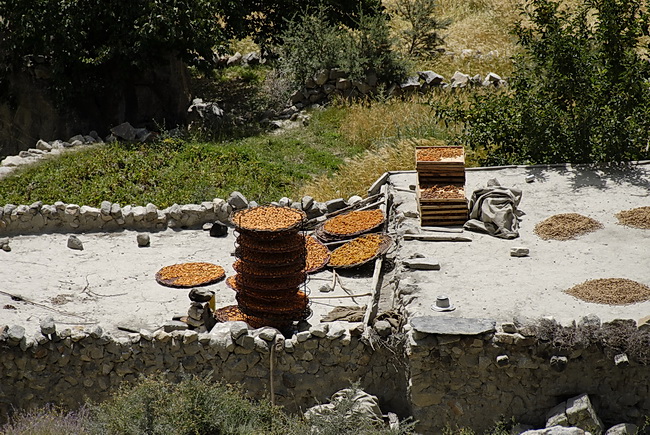 |
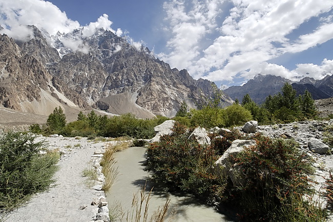
Das fünftägige Trekking beginnt in der Ortschaft Gulmit im Hunzatal auf etwa 2600 m Höhe. Die grünen Oasen werden aus einem ausgeklügelten Bewässerungssystem mit mineralreichem Gletscherwasser versorgt. Auf den Flachdächern trocknen Nüsse, Aprikosen und anderes Obst. The five days' trek started at the village of Gulmit in the Hunza Valley at around 2600 m. A sophisticated irrigation system is providing the green oasis with glacier water of high mineral contents. The flat roofs are used to dry nuts, apricots and other kinds of fruit. |
 |
Vier parallele Gletscher fließen in dieser Region von West nach Ost dem Hunzafluss zu: Der Gulmit-, Ghulkin-, Pasu- und der Baturagletscher. Die Zunge des Ghulkingletschers wird hier nordwärts gequert. Four parallel glaciers are floating towards the Hunza River in direction from west to east. These are Gulmit- Ghulkin, Pasu- and Batura Glacier. At first we had to cross the tongue of the Ghulkin Glacier. |
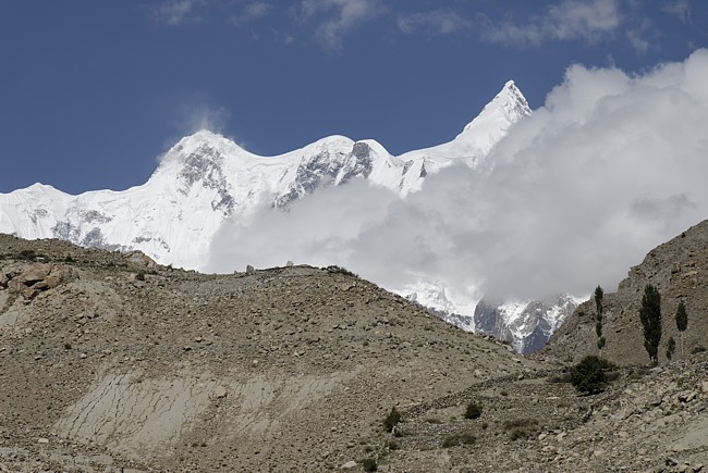 |
Vom Karakorum Highway aus ist nur die Stirnmoräne des Ghulkingletschers zu sehen. Der Gletscher (19 km lang) entspringt am wildesten Gipfel des Batura Muztagh, dem Shispare (7611 m) rechts über den Wolken. Links der Ghenta Peak (7100 m). From the Karakoram Highway only the front moraine of the Ghulkin Glacier is visible. The Glacier itself (19 km long) begins at Shispare (7611 m - right above the clouds), one of the most savage peaks of the Batura Range. The summit on the left is Ghenta Peak (7100 m). |
 |
Von der Moräne des Ghulkingletschers steigt man hinunter zum Borith See. Im Hintergrund der gezackte Ostgrat des Ultar Peaks. Descending the moraine of the Ghulkin Glacier we passed Borith Lake. In the background the jagged east ridge of Ultar Peak. |
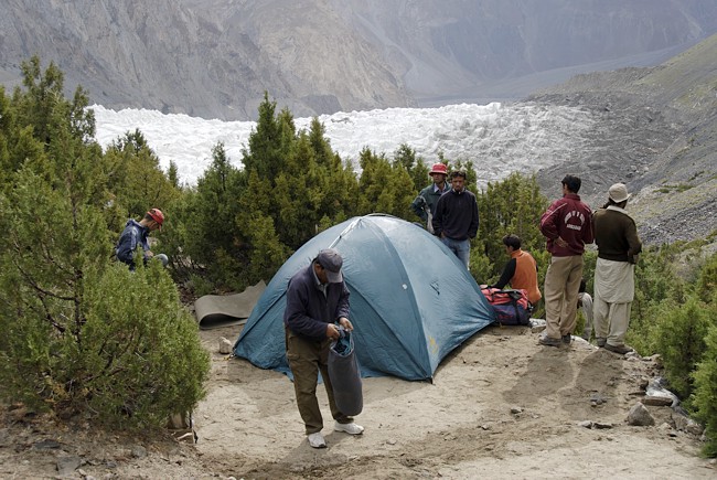 |
Unser erstes Lager auf der Moräne des 28 km langen Pasugletschers. Our first camp on the moraine of the 28 km Pasu Glacier. |
 |
Der Pasugletscher kann in seiner vollen Länge vom Karakorum Highway eingesehen werden. Er strömt von den Hängen des Pasu Diar (7284 m) herunter, der breite Gipfel (Pasu Sar East 6842m) ist nur der Abbruch eines Firnplateaus. Vom Pasu Diar ist über der Mitte des Firnhanges nur die Spitze zu sehen. From the Karakoram Highway we could see the Pasu Glacier in its full length. It is flowing down from the slopes of Pasu Diar (7284m), the summit behind the broad peak (Pasu Sar East 6842 m) in the center which in fact only is the rim of a large snow plateau. |
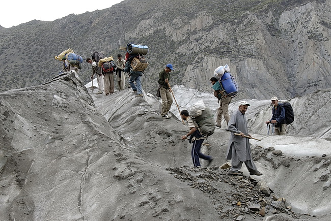
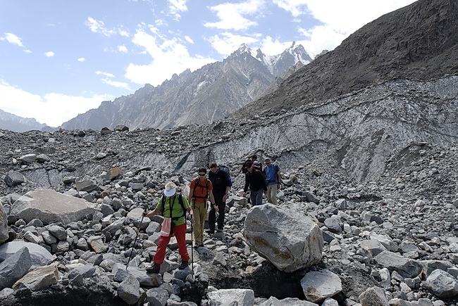
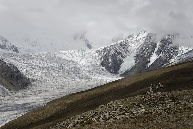
Die nächste Etappe führte uns zunächst auf das schuttbedeckte Eis des Pasugletschers. Die Querung des etwa 1 km breiten Pasugletschers ist ohne Steigeisen stellenweise mühsam.
On the next morning the first thing to do was to cross the debris-covered Pasu Glacier. Parts of the 1 km crossing of the Pasu Glacier are quite arduous to go without crampons.
 |
 |
 |
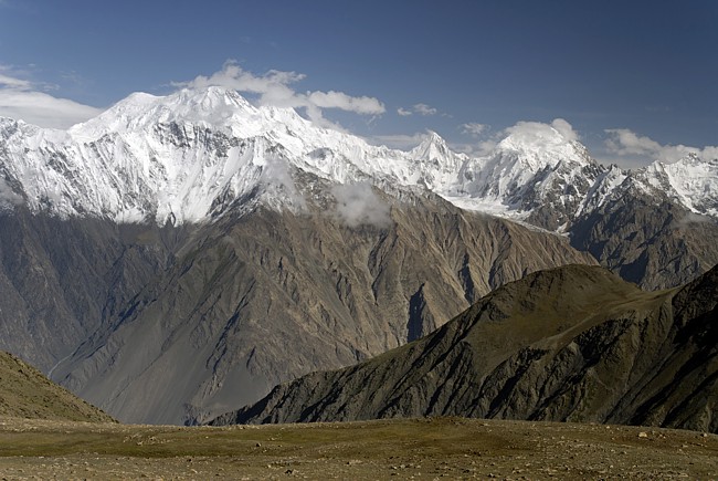
Den breiten Patundasrücken erreicht man auf einer Höhe von etwa 4000 m. Im Hintergrund das Tupopdanmassiv mit den Pasu-Kathedralen (6100 m), daneben der Eisfall des Pasugletschers. At an altitude of about 4.000 m we finally reached the Patundas Ridge. In the background we can see the Tupodan Range and the Pasu Cathedrals (6.100 m) as well as the ice-fall of the Pasu Glacier. |
 |
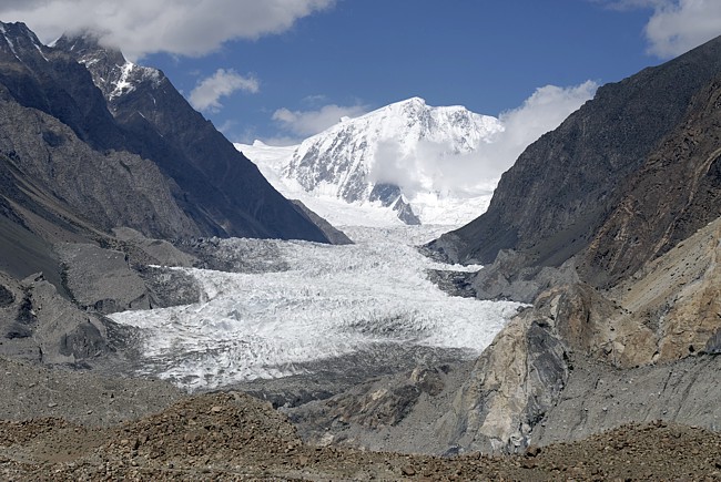
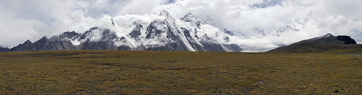
Erster Blick zum Baturagletscher. Die Berge gehören zum Kukmassiv, knapp 7000 m hoch, nordwestlich der Baturamauer. Hinter diesen Bergen beginnt der Hindukusch. First view of the Batura Glacier. The mountains in the background belong to the Kuk Massive (~ 7.000 m) north-west of the Batura Wall and mark the border to the Hindukush Range behind. |
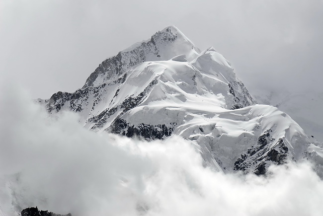
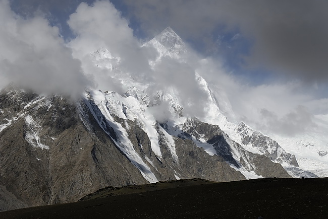
Der abgeflachte Patundasrücken geht fast unvermittelt in bizarre Eisgipfel über, von r.n.l.: Hiriz (5500m), Darmyani Peak (6095m), Noukarsich (6498m) und der Passu East (6842m) im Hintergrund.
The flat ridge of Patundas is changing abruptely into namless ice peaks: from right to left.: Hiriz (5500m), Darmyani Peak (6095m), Noukarsich (6498m) und Passu East (6842m) in the background.
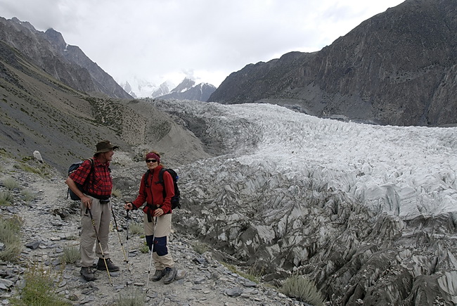
Borchers Peak (6305 m) above the Pasu Glacier. The snow-line in this area is at about 4700 m.
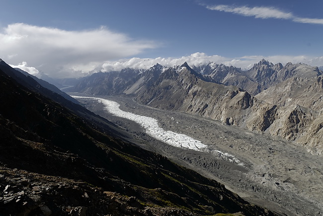 |
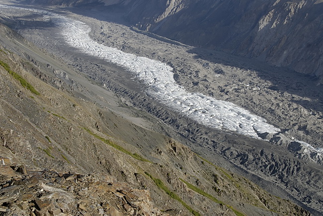
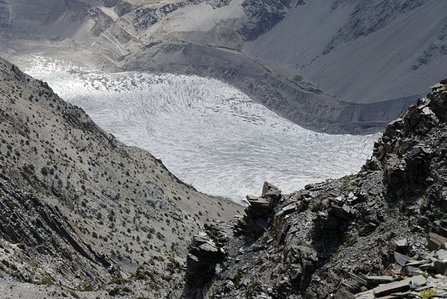
Weiter führt der Weg hinunter zum 58 km langen Baturagletscher, von dem man hier etwa die Hälfte überblickt. The path is now leading down to the 58 km Batura Glacier which is visible here in about half of its length. |
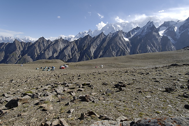 |
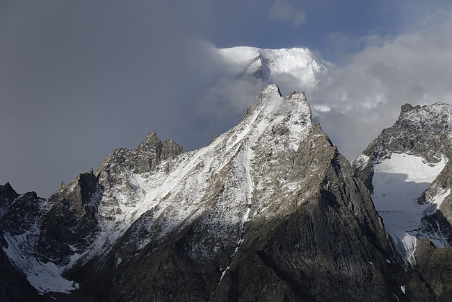
Letztes Zeltlager auf dem Patundasrücken. Rechts in den Wolken der Ultar Peak, links im Hintergrund der Spantik.
The final camp on top of the Patundas Ridge. Ultar Peak is partly cloud covered (right), behind it to the left we can spot the summit of Spantik. |
 |
Blick vom Patundasrücken nach Osten zum Hispar Muztagh. Links der
Doppelgipfel des Lughpar Sar (7200 m), daneben der Momhil Sar (7343 m -
in Wolken). Die Pyramide (6725 m) und der breite Gipfel rechts (6493 m)
tragen keine Namen. View in eastern direction towards Hispar Muztagh. To the left the twin peaks of Lughpar Sar (7200 m), and right of it Momhil Sar (7343 m) still hidden by clouds. The pyramide (6725 m) and the broad snow peak on the right side (6493 m) do not have names as far as we know. |
 |
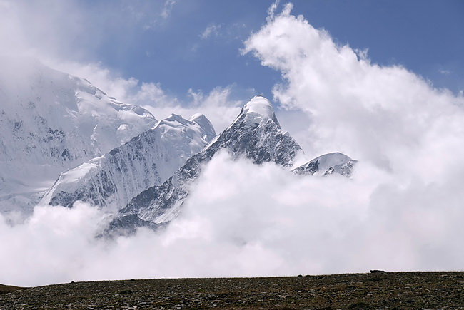
Wenn sich der Nebel etwas lichtet erscheint im Hintergrund der Ultar
Peak (7350m) und im Vordergrund die Ghulkin Pyramide (5120m). As the fog was clearing Ultar Peak (7350m) appeared behind the Ghulkin Pyramid (5120m). |
Die Talsohle mit dem Baturagletscher liegt hier etwa 3000 m hoch. Bis zum Karakorum Highway talauswärts sind es noch rund 5 km.Bevor es zum Baturagletscher hinunter geht zeigt sich noch einmal die Pyramide des Shispare (7611m) mit seiner Nordflanke.
The Batura Glacier is situated at an altitude of 3000 m. From there it is still 5 km to go to reach the Karakoram Highway. Before descending to the Batura Glacier we had a quick view of Shispare (7611m) and its north face.

Der Abstieg zum letzten Lager führte zunächst über teilweise ausgesetzte Schieferhänge mit allerdings herrlichen Tiefblicken. Das letzte Wegstück ist dann ohne weitere Schwierigkeiten.
On the descent to our final camp we had to cross slate slopes which were a little bit airy in some parts. Nevertheless we had fascinating views of the glacier below. The final part of the descent is easy.


Vom Ende des Baturagletschers erkennt man im
Nordwesten in den Wolken den Kuk Sar (6935 m). Vor diesem Massiv biegt
das Tal des Batura nach Südwesten und dann wieder nach Nordwesten
ab, wo der Ursprung des Gletschers an den Osthängen des Kampire
Dior (7143 m) liegt. Der 6059 m hohe Gipfel im rechten
Bild ist lediglich eine Erhebung in einem Grat der nach Norden vom
Baturakamm herunter zieht.
View across the Batura Glacier in north-western
direction towards Kuk Sar (6935 m - partly in clouds) where the glacier
turns left and has its origin at the eastern slopes of Kampire Dior
(7143 m). The summit in the right picture (6059 m) is just a
part of the ridge that comes down from the Batura Ridge in northern
direction.
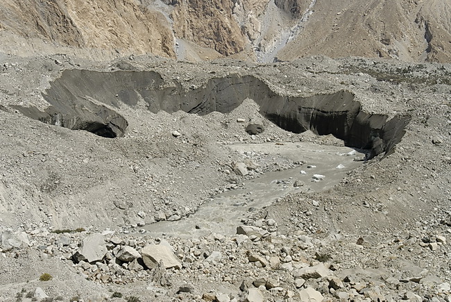
Gletschertor des Baturagletschers. Nach Aufbruch aus dem letzten Zeltlager sind es noch sind es einige Kilometer bis zur Strasse.
The mouth of the Batura Glacier. After leaving our final camp we still had some kilometers to go to reach the road.